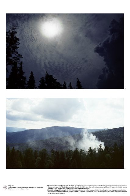
 |
'The Beskid Mały Range - story in trees written'
'Enclaves of the oldest tree stands with participation of a silver fir Abies alba MILL. in the landscape of the Beskid Mały Range' ALICJA BARĆ
University of Silesia, Faculty of Biology and Environmental Protection,
Department of Geobotany and Nature Protection; Jagiellońska28, 40-032 Katowice
e-mail: abarc@us.edu.pl
|
Description popularizing the research project
In Beskid Mały a small range of Polish Carpathian Mountains a chronicle is being written on a noble parchment of an eternal stand of trees. The oldest enclaves of fir forests are like me-dieval tomes telling us directly and indirectly about the past world. Younger, only 80-years-old beech and fir trees also tell a story, as they sough in places where violent winds of history, politics and economics torn precious pages of the chronicle together with large stretches of the Carpathian forest. Naked slopes were to be covered with spruces but they could not resist strong winds, snow heaps and insects.
That is how Carpathian environment rejected a puny graft tainted with human ignorance and greed.
In today's tree stands, which were reconstructed to resemble composition of the oldest parts of the forest, history of the mountains, men and trees is synchronized with the eternal rhythm of the Universe. Time is measured in misty dusks and dawns, in seasons and eclipses. And in the background the monumental crowns of firs still sough.
Abstract
Landscape values of the Beskid Mały were estimated when in 1998 the Landscape Park of the Beskid Mały Range was established. Its western and eastern parts belong to the Silesian voivodeship.
The history of forest cover in this area developed dramatically and still keeps hidden many blanks. The Author has acknowledged enclaves of fir forests as one of the most valuable forest communities in the whole Beskid Mały. These were searched out in the field basing on the Franz-Joseph's military charts from the years 1861/1862, Polish maps of the Military Geographical Institute from 1934 and contemporary maps used in forestry.
Beskid Mały, a small mountain range, covers approximately 400 km2. It is situated between: Bielsko-Biała, Andrychów, Wadowice, Sucha Beskidzka and Żywiec. An almost horizontal ravine of the Soła river divides it into: western (small) and eastern (large) parts; the latter one is called the Zasolskie Mountains or the Kocierski Beskid. The Skawa river makes its eastern boundary in picturesque meanders.
Beech, mixed beech-fir and fir forests have been developed here on the background of the Carpathian Flysch. Since the middle of the 19th century these forests were intensively managed. Ideas influencing forestry, ownership structure and economic situation resulted in the decrease of the area covered with forests of natural origin. Simultaneously, the area of spruce monocultures increased. However, these did not preponderate over the landscape of the Beskid Mały, because snow formations on their branches and stems, strong winds, as well as insects, destroyed them. This was a catastrophe; so in the 20's and the 30's of the 20th century the reconstruction of tree species composition in forests became an urgent necessity. These large-scale activities were continued in post-war period by the State Forests. The final effect of the efforts was rebuilding the majority of changed forests into one typical for the Beskides' lower montane and colline zones.
So, this time again, a man managed to remedy his mistakes.
