 |
'Silesia seen from orbit'
'Influence of natural and anthropogenic factors on condition and dynamism of landscape in selected areas of Poland and Europe by means of remote sensing methods' LESZEK KOLONDRA
University of Silesia, Faculty of Earth Sciences,
Divisiont of Remote Sensing of Environment; Będzińska 60, 41-200 Sosnowiec
e-mail: kolondra@wnoz.us.edu.pl
|
Description popularizing the research project
Everybody who was in the area between Cracow, Częstochowa, Katowice and Żywiec on August 28, 1992 is now in a peculiar family picture. Without warning, without saying 'cheese' a candid camera took a picture of us then. The camera was hidden well in the sky, in the orbit around the Earth. Do not bother to look for yourself in the picture. You will not find even such characteristic for Silesia objects as heaps, chimneys and shafts. Maybe you will notice some light spots in the middle. It is the sand pit in Jaworzno Szczakowa. Even the mountain peaks of Beskidy are lost in the colourful patchwork which resembles microscopic pictures of body tissues, a postcard from the seaside or a fragment a painting by some impressionist, depending on who is looking at it.
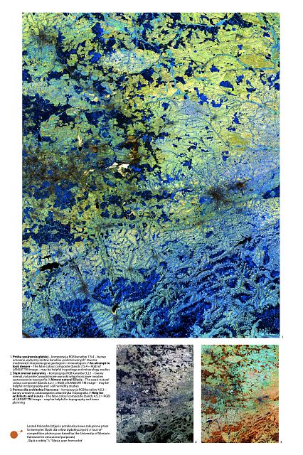
The Silesian part of the Blue Planet does not necessarily have to be blue. It does not have to be black as well. It may be full of colours and shades depending on needs. Pictures of Silesia in its natural colours after digital processing are used in topography. Infrared pictures help to monitor condition of forests whereas geologists and mineralogists prefer pictures where IR is excluded.
The picture which covers a few thousand square kilometres is no bigger than an average calendar, gives almost unlimited interpreting possibilities to hydrographers, town-planners and other specialists.
Who knows maybe in future (the resolution of photos taken by spy satellites is really amazing) the pictures will be used in measuring the feel-good factor? So. Say 'cheese'. You are in a candid camera.
Abstract
The showed photographs are selected false colour (red, green, blue) RGB composites of a LANDSAT TM image which was acquired on 28 August 1992 over Silesia region. A complete image includes: area approx. of 31 500 km2 (175 x 180 km). The included photographs represent only a sub-area of the whole image (from Żywiec to Częstochowa in northern direction and from Katowice to west side of Niepołomicka Wood in the eastern direction). The composites present a terrain in false colour giving much more possibilities in detection and classification of land features which are not visible on classic panchromatic or colour photographic emulsions.
Knowledge of usefulness of various composition features makes it possible for specialists (topography, geology, mineralogy, geomorphology, hydrology, spatial planning, forestry) to acquire much more credible data in a more economical and comfortable way.
The LANDSAT TM image was acquired by the University of Silesia for educational and research purposes. At present, the image is still used in investigations by Geomorphology Department ("Influence of natural and anthropogenic factors on conditions and dynamism of landscape in selected areas of Poland and Europe by means of remote sensing methods").
